
Dilapidation Survey: The Essential Guide to Property Protection in 2026
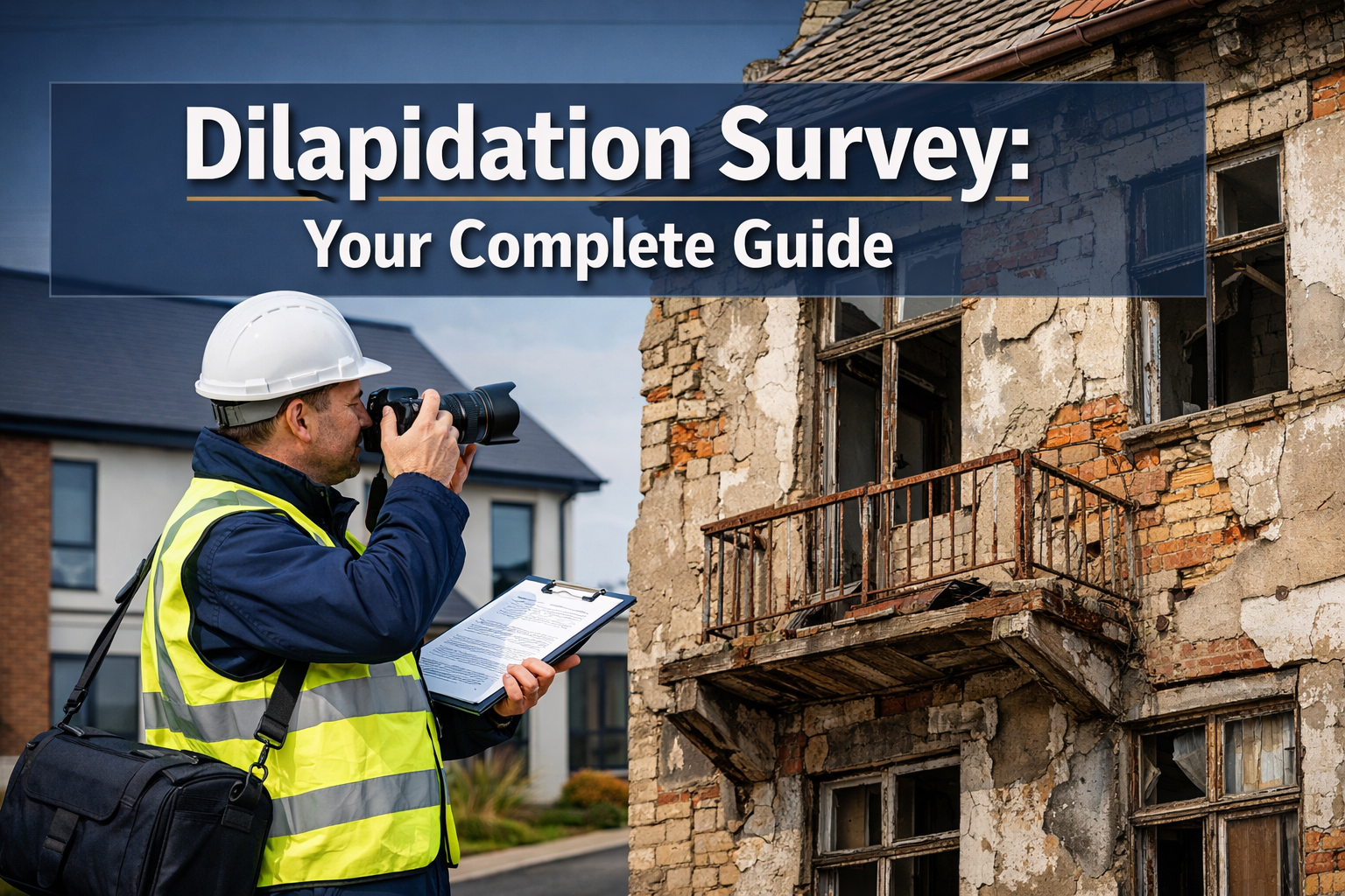
When construction work begins next door to your property, how can you prove that the cracks in your wall weren’t already there? The answer lies in a dilapidation survey—a critical protective measure that thousands of property owners overlook until it’s too late. In 2026, as urban development accelerates and construction projects multiply across cities, understanding this specialized property assessment has never been more important for safeguarding your investment.
A dilapidation survey provides an independent, detailed record of a property’s condition before construction, demolition, or renovation work begins nearby. This baseline documentation becomes invaluable evidence if disputes arise about who caused damage to neighboring properties[1].
Key Takeaways
- 📋 Dilapidation surveys create a detailed baseline record of property conditions before construction work begins, protecting all parties from false damage claims
- 🏗️ These surveys are frequently required by councils and local authorities for excavation, demolition, and large-scale construction projects
- 📸 Modern surveys utilize advanced technology including geolocated photographs, 360° site capture, and web-based platforms for comprehensive documentation[2]
- ⚖️ The primary benefit is dispute prevention—providing neutral, third-party evidence that can save thousands in legal costs
- 🔍 Professional surveyors document conditions through photographs, written descriptions, measurements, annotated diagrams, and detailed inspection notes[1]
What Is a Dilapidation Survey?
A dilapidation survey is a comprehensive property inspection that documents the existing condition of buildings and structures before potentially disruptive work takes place. Think of it as a detailed “snapshot in time” that captures every crack, stain, defect, and structural characteristic of a property.
This specialized assessment serves as protective evidence for property owners, contractors, and developers alike. By establishing a clear baseline, the survey distinguishes pre-existing damage from any new damage that might occur during construction activities[1].
The Core Purpose
The fundamental purpose of conducting a dilapidation survey is risk mitigation. When construction, excavation, or demolition work happens near a property, vibrations, ground movement, and other disturbances can potentially cause structural damage. Without proper documentation of the property’s condition beforehand, determining responsibility becomes a contentious and expensive battle.
Professional commercial dilapidation surveys provide this crucial protection by creating an irrefutable record that all parties can reference if concerns arise.
Types of Dilapidation Surveys
Not all dilapidation surveys serve the same purpose. Understanding the different types helps property owners select the appropriate assessment for their situation.
Pre-Construction Dilapidation Surveys
These surveys occur before any construction work begins on or near a property. They’re the most common type and serve as protective documentation for neighboring properties that might be affected by:
- Foundation excavation
- Demolition activities
- Heavy machinery operation
- Pile driving and ground works
- Large-scale renovations
Pre-construction surveys are often mandated by councils and local authorities under planning permits, particularly for infrastructure and government projects[1].
Lease Dilapidation Surveys
Common in commercial property leasing, these surveys assess a property’s condition at the beginning or end of a lease term. They help determine whether tenants have fulfilled their repairing obligations as outlined in the lease agreement.
A detailed schedule of dilapidations lists all repairs and maintenance work required to return the property to its agreed condition.
Interim Dilapidation Surveys
Conducted during ongoing construction work, interim surveys monitor the property’s condition at regular intervals. This progressive documentation helps identify when damage occurs, making it easier to establish causation and responsibility.
Post-Construction Dilapidation Surveys
These surveys take place after construction work completes, allowing direct comparison with the pre-construction baseline. Any new damage or deterioration becomes immediately apparent through side-by-side comparison of the documentation.
Who Needs a Dilapidation Survey?
Multiple parties benefit from commissioning professional dilapidation surveys:
Property Owners 🏠
- Residential homeowners with construction happening nearby
- Commercial property owners protecting their investments
- Landlords documenting property condition for lease agreements
Developers and Contractors 🏗️
- Construction companies working near existing structures
- Developers undertaking large-scale projects
- Demolition contractors
Councils and Authorities 🏛️
- Local government bodies overseeing development
- Planning departments issuing permits
- Infrastructure project managers
Strata and Body Corporates 🏢
- Multi-unit residential complexes
- Commercial building management
- Shared property arrangements
Professional chartered surveyors in London and surrounding areas regularly conduct these assessments for all these client types.
Key Components of a Comprehensive Dilapidation Survey
A thorough dilapidation survey includes multiple documentation elements that work together to create an indisputable record[1].
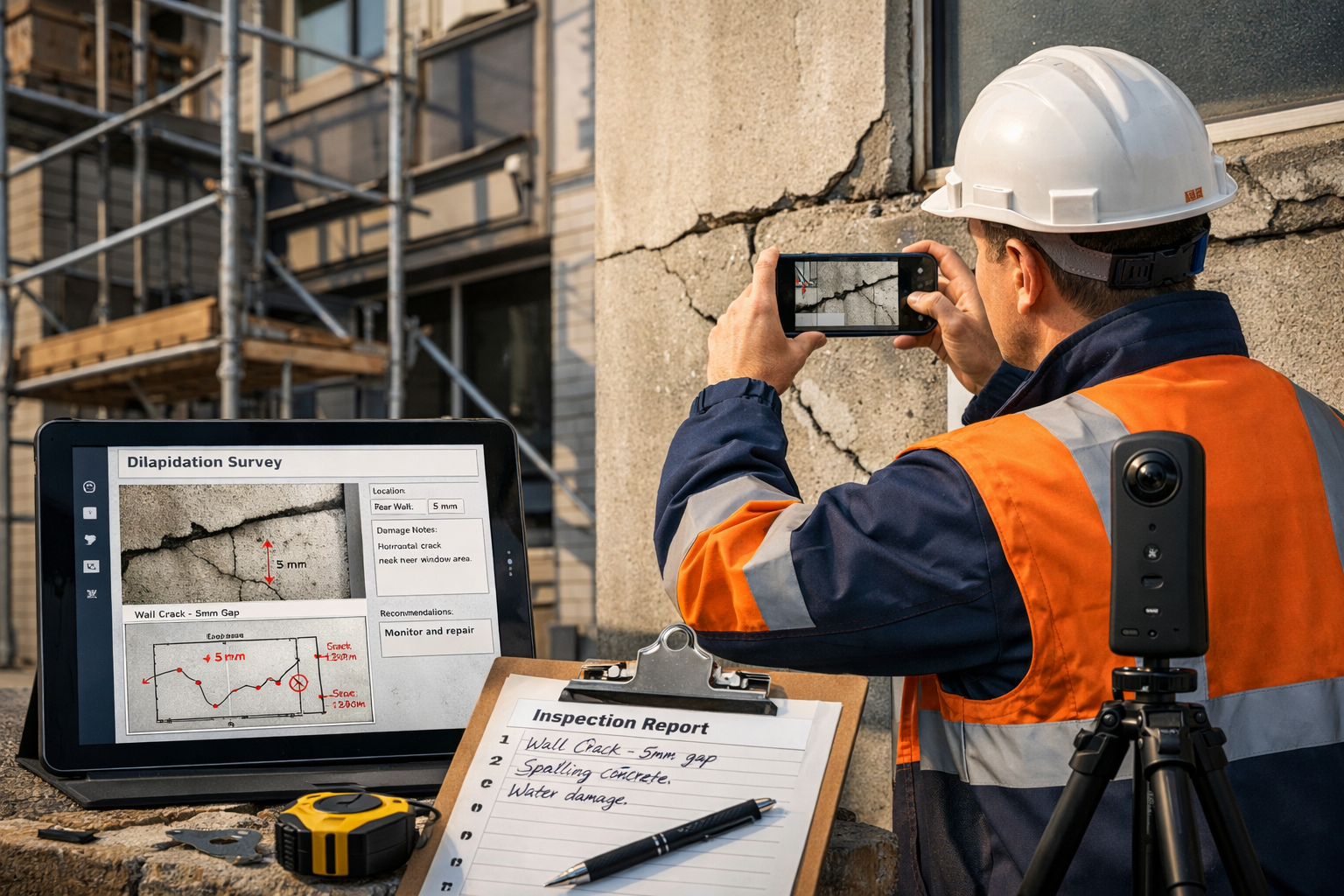
Photographic Evidence
High-quality photographs form the visual foundation of any dilapidation survey. Modern surveys employ:
- Geolocated photographs that record exact position data
- 360-degree site capture for comprehensive spatial documentation
- Detailed close-ups of specific defects and damage
- Wide-angle shots showing overall property context
- Timestamped images proving when documentation occurred[2]
Written Descriptions
Comprehensive written reports complement visual documentation by providing:
- Detailed condition descriptions for each area
- Professional assessment of defect severity
- Technical terminology for structural elements
- Observations about materials and construction quality
- Notes on existing repairs and modifications
Measurements and Dimensions
Precise measurements establish quantifiable baselines:
- Crack widths and lengths
- Settlement measurements
- Displacement distances
- Structural deflection readings
- Room dimensions and floor levels
Annotated Diagrams and Floor Plans
Visual diagrams enhance understanding by showing:
- Damage locations marked on floor plans
- Structural element identification
- Measurement reference points
- Photographic viewpoint positions
- Access routes and survey areas
Inspection Notes and Observations
Professional surveyors record detailed notes including:
- Weather conditions during inspection
- Access limitations encountered
- Areas not inspected and reasons why
- Recommendations for monitoring
- Identified risks and concerns
Risk Assessments
Forward-looking risk analysis identifies:
- Vulnerable structural elements
- Potential failure points
- Areas requiring monitoring during construction
- Recommended protective measures
- Insurance considerations[1]
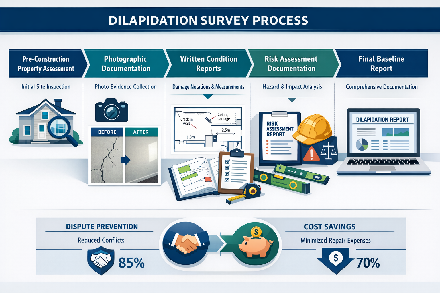
The Dilapidation Survey Process: Step by Step
Understanding the survey process helps property owners prepare effectively and ensure comprehensive documentation.
Step 1: Initial Consultation and Scope Definition
The process begins with discussing project requirements, identifying properties to be surveyed, and establishing the survey scope. This includes determining which neighboring properties might be affected by planned construction work.
Step 2: Pre-Survey Research
Professional surveyors review:
- Property records and plans
- Previous survey reports
- Building consent documentation
- Construction project details
- Historical property information
Step 3: Site Inspection
The physical inspection typically includes:
- External assessment of building facades, roofs, foundations, and grounds
- Internal inspection of walls, ceilings, floors, and structural elements
- Detailed documentation using photographs, measurements, and notes
- Technology deployment including 360° cameras and digital platforms[2]
Step 4: Documentation Compilation
Surveyors compile all collected information into:
- Organized photographic records
- Comprehensive written reports
- Annotated diagrams and plans
- Measurement data tables
- Risk assessment summaries
Step 5: Report Delivery
The final deliverable includes:
- Professional survey report
- Digital documentation package
- Web-based platform access for remote exploration[2]
- Recommendations for monitoring
- Baseline evidence for future reference
Qualified dilapidation surveyors in London follow these systematic procedures to ensure thorough, defensible documentation.
Technology Transforming Dilapidation Surveys in 2026
The surveying industry has embraced digital innovation, making dilapidation surveys more comprehensive and accessible than ever before.
Digital Documentation Platforms
Modern surveys utilize web-based platforms that enable:
- Remote site exploration without physical visits
- Collaborative review by multiple stakeholders
- Secure cloud storage of all documentation
- Easy comparison between pre and post-construction conditions
- Mobile accessibility from any device[2]
Advanced Photography Systems
Contemporary surveys employ:
- High-resolution digital cameras with GPS tagging
- 360-degree panoramic capture systems
- Drone photography for roof and elevated areas
- Thermal imaging for hidden defects
- Time-lapse photography for monitoring
Measurement Technologies
Precision tools include:
- Laser distance measurers
- Digital crack width gauges
- Electronic levels and inclinometers
- 3D scanning equipment
- Ground-penetrating radar
Data Management Systems
Sophisticated software enables:
- Automated report generation
- Standardized documentation templates
- Database management of survey records
- Comparative analysis tools
- Integration with project management systems
Legal and Regulatory Considerations
Dilapidation surveys operate within specific legal frameworks that vary by jurisdiction.
Regulatory Requirements
In many regions, councils require dilapidation surveys for:
- Excavation work exceeding certain depths
- Demolition of structures above specified sizes
- Large-scale construction projects
- Infrastructure development
- Government-funded projects[1]
Planning permits often mandate these surveys as a condition of approval, ensuring neighboring properties receive appropriate protection.
Legislative Developments
Recent legislative activity highlights the importance of property condition documentation. For example, California’s AB1183 (2025-2026 legislative session) addresses landlord responsibilities regarding property dilapidation, though specific implementation details continue to evolve[4].
Dispute Resolution
When disagreements arise about construction damage, dilapidation surveys provide:
- Neutral evidence from independent third parties
- Baseline documentation showing pre-existing conditions
- Professional opinions from qualified surveyors
- Photographic proof that’s difficult to dispute
- Cost-effective resolution avoiding lengthy litigation[1]
This evidence significantly strengthens legal positions and often facilitates faster, more amicable settlements.
Benefits of Professional Dilapidation Surveys
Investing in a comprehensive dilapidation survey delivers multiple advantages for all parties involved.
Dispute Prevention 🛡️
The primary benefit is avoiding conflicts before they start. Clear documentation eliminates ambiguity about pre-existing conditions, removing the foundation for most damage disputes[1].
Financial Protection 💰
Professional surveys protect against:
- False damage claims
- Unfair repair costs
- Insurance complications
- Legal expenses
- Property devaluation
Project Confidence 📊
Developers and contractors gain:
- Protection from unfounded allegations
- Evidence supporting due diligence
- Smoother project progression
- Better stakeholder relationships
- Reduced project risk
Insurance Support 📋
Survey documentation assists with:
- Insurance claim substantiation
- Premium negotiations
- Risk assessment
- Coverage verification
- Claims processing
Peace of Mind 😌
Property owners enjoy:
- Confidence in their protection
- Reduced stress about nearby construction
- Professional support if issues arise
- Documented property history
- Valuable property records
Choosing the Right Surveyor for Your Dilapidation Survey
Selecting a qualified professional ensures comprehensive, defensible documentation.
Essential Qualifications
Look for surveyors with:
- Professional accreditation from recognized bodies (RICS, CIOB, etc.)
- Specialist experience in dilapidation surveys
- Local knowledge of regional requirements
- Professional indemnity insurance
- Proven track record with verifiable references
Questions to Ask Potential Surveyors
Before commissioning a survey, inquire about:
- How many dilapidation surveys have you completed?
- What technology and methods do you use?
- What does your final report include?
- How long will the survey and report take?
- What is your fee structure?
- Can you provide references from similar projects?
- Are you familiar with local council requirements?
- Will you provide expert witness services if needed?
Geographic Considerations
Choose surveyors with local expertise in your area, whether you need services in Surrey, Hertfordshire, or other regions.
Cost Factors for Dilapidation Surveys
Understanding pricing helps budget appropriately for this protective measure.
Factors Affecting Survey Costs
Several variables influence the final price:
| Factor | Impact on Cost |
|---|---|
| Property size | Larger properties require more time and documentation |
| Property complexity | Multiple structures, difficult access increase costs |
| Survey scope | Internal and external surveys cost more than external only |
| Number of properties | Multiple neighboring properties multiply survey requirements |
| Urgency | Expedited surveys command premium pricing |
| Location | Urban areas typically have higher rates |
| Technology requirements | 360° capture and advanced tools add costs |
| Report detail level | Comprehensive reports require more surveyor time |
Typical Investment Range
While costs vary significantly based on the factors above, property owners should generally expect:
- Small residential properties: £500-£1,500
- Medium residential properties: £1,500-£3,000
- Large residential properties: £3,000-£6,000+
- Commercial properties: £2,000-£10,000+
- Multiple properties: Costs multiply but may include volume discounts
Cost-Benefit Perspective
When considering survey costs, remember that:
- Legal disputes can cost £10,000-£100,000+
- Unfair damage claims may exceed £50,000
- Insurance complications can be financially devastating
- Professional surveys typically cost less than 1% of potential dispute costs
The investment in a dilapidation survey represents exceptional value compared to the financial risks it mitigates[1].
Common Dilapidation Survey Scenarios
Understanding typical situations helps recognize when surveys are necessary.
Scenario 1: Basement Excavation Next Door
Your neighbor plans to excavate for a basement extension. The deep excavation and potential ground movement pose risks to your property’s foundations. A pre-construction dilapidation survey documents your property’s current condition, protecting you if cracks or settlement occur.
Scenario 2: Major Infrastructure Project
A council-approved road widening project will involve heavy machinery and vibration near your commercial property. The local authority requires a dilapidation survey as part of the planning consent, ensuring proper documentation before work begins[1].
Scenario 3: Commercial Lease Termination
A tenant’s lease is ending on your commercial property. The lease agreement requires the tenant to return the property in good condition. A lease dilapidation survey compares current conditions against the original condition documented at lease commencement, identifying required repairs.
Scenario 4: Demolition Project
A developer is demolishing an adjacent building. The demolition process involves heavy equipment, controlled explosions, and significant vibrations. A comprehensive survey protects both the developer and neighboring property owners.
Scenario 5: Multi-Unit Development
A large residential development is planned near your home. The construction will span 18 months with extensive groundwork, pile driving, and heavy vehicle traffic. An initial survey establishes baseline conditions, with interim surveys monitoring any changes during construction.
What Happens After the Survey?
Understanding post-survey procedures ensures you maximize the documentation’s value.
Report Review and Distribution
Once completed, the survey report should be:
- Reviewed thoroughly by all stakeholders
- Distributed to relevant parties (property owners, contractors, councils)
- Stored securely in multiple locations
- Backed up digitally for long-term preservation
- Made accessible to insurance providers if needed
Monitoring During Construction
For ongoing projects, establish:
- Regular inspection schedules
- Communication protocols for reporting concerns
- Contact procedures if damage is suspected
- Documentation processes for new observations
- Interim survey timing
Post-Construction Comparison
After construction completes:
- Commission a post-construction survey
- Compare findings against the baseline documentation
- Identify any new damage or deterioration
- Document causation evidence
- Initiate resolution processes if necessary
Dispute Resolution Procedures
If damage disputes arise:
- Review baseline documentation from the original survey
- Engage the original surveyor for expert opinion
- Attempt negotiation using the evidence
- Consider mediation before litigation
- Prepare expert witness reports if legal action proceeds
Professional surveyors who conduct expert witness reports can provide crucial support during dispute resolution.
Dilapidation Surveys vs. Other Property Surveys
Understanding how dilapidation surveys differ from other assessment types clarifies their specific purpose.
Dilapidation Survey vs. Building Survey
A building survey (structural survey) assesses a property’s overall condition for purchase decisions, identifying defects and repair needs. A dilapidation survey specifically documents condition at a point in time for comparison purposes, not to advise on purchase suitability.
Dilapidation Survey vs. Condition Report
Condition reports provide general property assessments. Dilapidation surveys offer more detailed documentation with specific focus on establishing baseline evidence for potential disputes.
Dilapidation Survey vs. Boundary Survey
Boundary surveys establish property lines and ownership limits. Dilapidation surveys document structural and cosmetic property conditions, regardless of boundary locations.
Dilapidation Survey vs. Subsidence Survey
Subsidence surveys investigate specific ground movement issues and their causes. Dilapidation surveys may document subsidence evidence but focus on comprehensive condition recording rather than cause investigation.
Best Practices for Property Owners
Maximize the value of your dilapidation survey by following these recommendations.
Before the Survey
✅ Provide complete access to all property areas
✅ Clear obstructions that might prevent thorough inspection
✅ Compile relevant documentation (previous surveys, repair records)
✅ Communicate specific concerns to the surveyor
✅ Coordinate with neighbors if multiple properties need surveys
During the Survey
✅ Be available for questions and access assistance
✅ Point out known defects you want documented
✅ Allow adequate time for thorough inspection
✅ Avoid interfering with the surveyor’s methodology
✅ Take your own photographs as supplementary records
After the Survey
✅ Review the report carefully upon receipt
✅ Ask questions about anything unclear
✅ Store documentation securely in multiple locations
✅ Share with relevant parties (insurers, solicitors, contractors)
✅ Schedule follow-up surveys if construction is ongoing
Long-Term Documentation Management
✅ Maintain digital and physical copies of all reports
✅ Update property files with survey documentation
✅ Include surveys in property sale documentation
✅ Reference surveys in insurance policies
✅ Keep surveyor contact information for future needs
Industry Developments and Future Trends
The dilapidation survey field continues evolving with technological and professional advancements.
Artificial Intelligence Integration
AI-powered analysis is beginning to:
- Automatically identify defects in photographs
- Compare pre and post-construction images
- Generate preliminary condition reports
- Predict potential damage risks
- Streamline documentation processes
Drone Technology Expansion
Unmanned aerial vehicles now enable:
- Safe roof and chimney inspections
- Comprehensive external documentation
- Hard-to-access area assessment
- Cost-effective large property surveys
- High-resolution aerial photography
Drone roof surveys are becoming standard practice for comprehensive property documentation.
Building Information Modeling (BIM)
BIM integration allows:
- 3D property condition modeling
- Digital twin creation for monitoring
- Enhanced visualization of defects
- Better stakeholder communication
- Improved long-term documentation
Professional Standards Evolution
Industry bodies like RICS continue developing:
- Standardized survey methodologies
- Professional competency requirements
- Technology adoption guidelines
- Best practice frameworks
- Quality assurance protocols[5][6]
Conclusion: Protecting Your Property Investment
In 2026’s rapidly developing urban landscape, a dilapidation survey represents essential protection for property owners, developers, and contractors alike. This comprehensive documentation creates an irrefutable baseline record that prevents disputes, protects financial interests, and provides peace of mind during construction activities.
Whether you’re a homeowner with construction planned next door, a commercial property owner managing lease agreements, or a developer undertaking major projects, professional dilapidation surveys deliver exceptional value by mitigating risks that could cost tens of thousands of pounds.
The modest investment in a thorough survey—incorporating modern technology like geolocated photography, 360° capture, and digital platforms—provides protection far exceeding its cost[1][2]. By establishing clear, neutral evidence of property conditions before potentially disruptive work begins, these surveys eliminate ambiguity and create a foundation for fair resolution if concerns arise.
Your Next Steps
If you’re facing nearby construction, planning development work, or managing commercial property leases, take action now:
- Assess your risk exposure by identifying upcoming construction activities
- Consult qualified surveyors with dilapidation survey expertise
- Commission surveys early before construction work begins
- Review documentation thoroughly and store it securely
- Establish monitoring protocols for ongoing projects
Don’t wait until damage occurs to wish you had proper documentation. Contact experienced commercial property surveyors today to discuss your specific requirements and protect your valuable property investment with professional dilapidation survey services.
References
[1] Guide To Dilapidation Reporting Importance And Process – https://jimsbuildinginspections.com.au/blog/guide-to-dilapidation-reporting-importance-and-process/
[2] Watch – https://www.youtube.com/watch?v=1vxAWNvp5JM
[3] Surveys – https://www.dilapsolutions.com/services/surveys/
[4] legiscan – https://legiscan.com/CA/text/AB1183/2025
[5] Dilapidations For Surveyors – https://goreport.com/dilapidations-for-surveyors/
[6] Dilapidations Conference – https://www.rics.org/training-events/conferences/dilapidations-conference